Where Is 30A Located in the Florida Panhandle?

30A Community · Community Photo
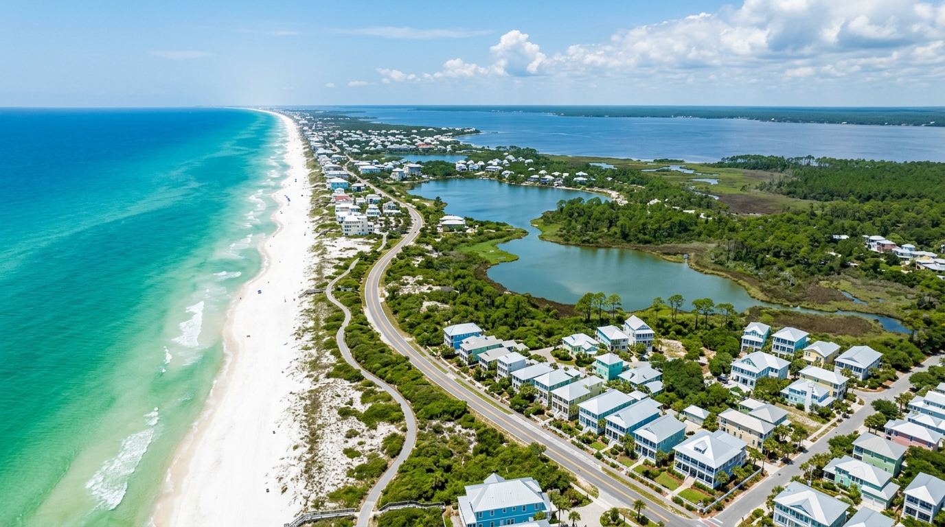
Scenic Highway 30A traces a 24‑mile ribbon of shoreline in South Walton County, threading pastel‑hued cottages, sugar‑white sands, and the emerald Gulf of Mexico. Nestled between the bustling resort towns of Destin to the west and Panama City Beach to the east, the corridor hugs the Gulf’s coastline while the Choctawhatchee Bay lies inland. The route showcases fifteen rare coastal dune lakes, a protected stretch of roughly 25,000 acres of state forests and parks, and the 18.5‑mile Timpoochee Trail that invites cyclists and walkers to explore from Dune Allen Beach to Inlet Beach. Visitors can breathe in the scent of salt air while passing iconic New‑Urbanist communities such as Seaside, Rosemary Beach, Alys Beach, and Grayton Beach, each reflecting the strict 50‑foot height limit that preserves open vistas. With zip codes 32459 and 32461 framing the entire stretch, the highway offers easy access to the Northwest Florida Beaches International Airport (ECP) and Destin‑Fort Walton Beach Airport (VPS), linking the tranquil peninsula to regional and national gateways. Whether you’re planning a vacation, scouting real‑estate, or simply marveling at one of Florida’s most distinctive coastal corridors, this scenic stretch provides a rare blend of natural beauty, deliberate design, and laid‑back coastal lifestyle.
Location Overview
The Scenic Highway 30A corridor stretches 24 miles throughSouth Walton Countyon theFlorida Panhandle, hugging the Gulf of Mexico betweenDestinto the west andPanama City Beachto the east. This low‑rise stretch is officially designated as Walton County Road30A (CR 30A), looping south off U.S. Highway 98 before rejoining the main highway at its eastern end.
Geographic Context
Because the road runs directly on the Emerald Coast, every mile offers beachfront views, tide‑influenced dunes, and access to the region’s 15 rare coastal dune lakes. The corridor’s strict 50‑foot height limit preserves an open, airy feel that contrasts sharply with the high‑rise commercial strips found in neighboring Destin and Panama City Beach.Why the Phrase Matters
Travelers often ask,where is 30a located in the florida panhandle, seeking a simple answer. The short reply is that the 30A corridor sits entirely within South Walton County, anchored by the Gulf shoreline and bounded by the two larger resort cities.
Official Designation
While the brand “30A” is used colloquially to describe a lifestyle destination, the roadway is a county‑maintained route that diverges from U.S. 98, follows the coast, and then reconnects, creating a scenic loop that defines the area’s identity.
Learn More
For detailed maps, community listings, and local business information, visit30A - A Place to Stay & Vacay.
Length
Scenic Highway 30A stretches for roughly 24 miles along the Gulf, offering a continuous ribbon of shoreline that defines the heart of the 30A corridor.
County
The entire route lies within South Walton County, a coastal jurisdiction that embraces the low‑rise, walkable villages that make the area distinct.
Region
Situated in the Florida Panhandle, the corridor is part of the Northwest Florida Emerald Coast, renowned for its turquoise waters and unspoiled beaches.
Location
From the western edge near Destin—about 20 miles away—to the eastern gateway of Panama City Beach roughly 15 miles east, the highway hugs the Gulf of Mexico, linking a string of charming beach towns.
Primary Access
Travelers reach the corridor primarily via US Highway 98, which runs parallel to Scenic Highway 30A and provides seamless connections to nearby airports and inland routes.
Distinctive Traits
The corridor is protected by a strict 50‑foot building height limit, preserving open gulf views, and is home to 16 unique beach communities that each contribute their own character.
30A Map of the Scenic Highway’s Beach Communities
West‑to‑East Route
Scenic Highway 30A diverges south from US‑98 at Dune Allen, travels east along the Gulf, and reunites with US‑98 at Inlet Beach on Walton County’s eastern edge. If you’re asking where is 30a located in the florida panhandle, the answer is the 24‑mile stretch of South Walton between Destin to the west and Panama City Beach to the east, anchoring a string of 30A beach towns.
Village Highlights
Dune Allen– A tranquil gateway with old‑Florida cottages and nearby Topsail Hill Preserve.
Blue Mountain– Rolling dunes and a relaxed, bohemian vibe.
Grayton Beach– Historic cottages, artistic studios, and immediate access to Grayton Beach State Park.
WaterColor– Master‑planned resort community built around Western Lake and shingle‑style architecture.
Seaside– America’s pioneering New Urbanist town, known for pastel cottages, walkable streets, and a central town square.
Seagrove Beach– Oak‑shaded lanes and a mix of classic beach shacks and newer homes.
WaterSound– Nautical‑shingle design within a private, master‑planned enclave.
Alys Beach– Stark white, Bermuda‑style homes governed by a strict design code.
Seacrest– Energetic town center with a large lagoon pool.
Rosemary Beach– European‑inspired grid, raised boardwalks, and brick‑paved lanes.
Inlet Beach– The eastern anchor, home to the open‑air 30Avenue market and close to Camp Helen State Park.
Nature and Walkability
The corridor is threaded by the 18.5‑mile Timpoochee Trail, encouraging pedestrian‑first travel and bike commuting between each beach community. Fifteen rare coastal dune lakes dot the landscape, offering freshwater snorkeling and wildlife viewing. County‑wide height limits of 50 feet preserve a low‑rise skyline, allowing unobstructed Gulf views from every village.
Why the Myth Matters
Despite the seamless feel of a single destination, 30A is not a municipality; each of the 16 beach towns operates under unincorporated Walton County governance. A detailed 30A map reveals that visitors are exploring a series of distinct beach communities, each with its own character and amenities.
Community / Town | Relative Position / Mile Marker | Architectural Style & Vibe | Standout Highlights |
|---|---|---|---|
Dune Allen Beach | Western entrance, at the far western end of the corridor where US‑98 branches off. | Tranquil, peaceful, old‑school beach vibe. | One of the 30A beach towns that showcases coastal dune lakes such as Allen Lake, Oyster Lake and Stallworth Lake, and sits close to Topsail Hill Preserve State Park. |
Santa Rosa Beach / Gulf Place | West‑central section, with Gulf Place centered at the intersection of 30A and County Road 393. | Eclectic, artistic, community‑focused. | Features local dining, boutique art galleries, open‑air green spaces, and outdoor amphitheater events at Gulf Place. |
Blue Mountain Beach | Just east of Gulf Place, situated on the higher terrain of the corridor. | Laid‑back, unpretentious, neighborhood‑centric. | Boasts the highest elevation on the Gulf (about 65 feet), artisanal bakeries, a local creamery, and striking coastal dune views. |
Grayton Beach | Central 30A, accessed via County Road 283 south of US‑98. | Historic, artsy, unstuffy, Bohemian “Old Florida.” | Renowned for the Red Bar, Grayton Beach State Park, pristine beach access, and the Western Lake coastal dune lake. |
WaterColor | Immediately east of Grayton Beach, before Seaside. | Southern coastal vernacular, upscale family‑resort feel, polished. | Offers Western Lake, the WaterColor Inn, an extensive network of scenic trails, and community pools and parks. |
Seaside | Center of the corridor, a flagship New Urbanism town. | Birthplace of New Urbanism, iconic pastel‑colored cottages, white picket fences. | Hosts a central outdoor amphitheater, the Airstream food‑truck row, and the house used in The Truman Show. |
Seagrove Beach | Between Seaside and WaterSound in the central‑east stretch. | Classic Florida beach vibe shaded by a lush canopy of ancient live oaks and pines. | Provides relaxed beach access paths and local seafood eateries. |
WaterSound | Eastern portion of 30A, just west of Alys Beach. | Cape Cod‑style shingle architecture with nautical, weathered‑wood aesthetic. | Features rolling sand dunes, private‑feeling boardwalks winding to the Gulf, and gated master‑planned tranquility. |
Alys Beach | East end, nestled between WaterSound/Seacrest and Rosemary Beach. | Bermudan and Moorish‑influenced architecture with crisp white courtyards. | Known for butter‑smooth white limestone masonry, iconic triangular white pillars, the Caliza pool, and striking visual symmetry. |
Seacrest Beach | Sandwiched between Alys Beach and Rosemary Beach at the eastern terminus. | Casual, high‑energy, family‑friendly resort layout. | Home to a 12,000‑square‑foot lagoon community pool, tram service to the beach, and informal eateries and courtyards. |
Rosemary Beach | Near the eastern terminus of the corridor. | West Indies neo‑traditional planning with Dutch‑Caribbean and French‑Creole influences. | Displays cobblestone pedestrian streets, brick‑paver plazas, boutique shopping, The Pearl Hotel, and charming green spaces. |
Inlet Beach | Eastern gateway where 30A meets US‑98. | Quiet, low‑key sandy stretch blending old‑Florida cottages with modern luxury builds. | Provides access to Camp Helen State Park, the outdoor shopping and dining hub 30Avenue, and Orange Street regional beach access. |
Coastal Dune Lakes, Timpoochee Trail in South Walton County
Geographic Setting
The Scenic Highway 30A corridor sits on the Emerald Coast of the Florida Panhandle, threading through South Walton County between the resort towns of Destin to the west and Panama City Beach to the east. This answers where is 30a located in the florida panhandle for travelers and investors alike.
Coastal Dune Lakes
Along the 24‑mile stretch sit fifteen coastal dune lakes, a globally rare geological formation found only in a handful of places such as northwest Florida, Madagascar, Australia, and New Zealand. Their brackish waters blend fresh rainwater with Gulf salt, and natural outfalls periodically link the lakes to the sea.
State Parks & Conservation
South Walton County’s commitment to preservation is evident in its state‑park system, which protects dunes, pine flatwoods, and additional dune lakes.
Grayton Beach State Park – 2,000‑acre dunes and Western Lake.
Topsail Hill Preserve – 1,600‑acre dunes, three lakes, untouched beach.
Deer Lake State Park – rare dune lake with boardwalk.
Camp Helen State Park – 180‑acre coastal preserve near Lake Powell.
These protected areas maintain the corridor’s natural character while offering recreational opportunities for hikers, paddlers, and wildlife watchers.
Timpoochee Trail
Running parallel to the highway, the 18.5‑mile Timpoochee Trail provides a paved, multi‑use path for cyclists, walkers, and runners from Dune Allen in the west to Inlet Beach in the east, linking beach towns and park entrances.
Planning & Skyline
Walton County enforces a strict 50‑foot building height limit across unincorporated South Walton, preserving sunlight, mature tree canopies, and a low‑rise skyline that lets the Gulf’s horizon remain visible from the beach.
How far is 30A from Destin, Panama City Beach, airports near
Driving Access
Drivers coming from the interstate typically followInterstate 10 (I‑10)eastward and exit south ontoFlorida State Road 85orUS‑331. Both routes connect toU.S. Highway 98, which runs parallel to the Gulf and serves as the main feeder for Scenic Highway 30A.
Entry Points to 30A
From US‑98, travelers can join 30A at either the western gateway nearDune AllenandTopsail Hillor the eastern gateway nearInlet Beach. These junctions give immediate access to the string of beach villages that define the corridor.
Air Travel Options
The region is served by two primary airports.ECP airport(Northwest Florida Beaches International) sits in Panama City Beach, roughly 25 to 35 miles northeast of the corridor. The drive from the airport to eastern 30A spots such as Rosemary Beach or Seaside typically takes 30‑40 minutes.VPS airport(Destin‑Fort Walton Beach) lies about 35 to 45 miles northwest, with a 45‑60 minute drive to western communities like Santa Rosa Beach and Dune Allen.
How far is 30A from Destin? Approximately 35 miles, translating to a 45‑minute drive from VPS airport.
How far is 30A from Panama City Beach? Roughly 30 miles, about a 35‑minute drive from ECP airport.
For travelers seeking convenience, the twoairports near 30Aprovide comparable options depending on whether a western or eastern destination is planned.
In short, the corridor’s easy connection via I‑10, State Road 85 or US‑331, plus the proximity of both ECP and VPS airports, answers the question ofwhere is 30a located in the florida panhandlewhile guiding visitors straight to the beach.
Origin / Departure Point | Distance to 30A (Miles) | Estimated Drive Time | Primary Route & Entrance |
|---|---|---|---|
How far is 30A from Destin | Approx. 20 miles west | 30–35 mins | US‑98 East into West 30A |
How far is 30A from Panama City Beach | Approx. 15 miles east | 20–30 mins | US‑98 West into East 30A |
Airports near 30A – ECP airport | Approx. 25–35 miles | 30–40 mins | FL‑388 W to FL‑79 S to US‑98 W to East 30A |
Airports near 30A – VPS airport | Approx. 35–45 miles | 45–60 mins | FL‑85 S to FL‑293 Toll / Mid‑Bay Bridge or US‑98 E to West 30A |
Pensacola | Approx. 65–75 miles | 1 hr 30 mins | I‑10 E to US‑331 S or US‑98 E |
Tallahassee | Approx. 110–120 miles | 2 hours | I‑10 W to US‑331 S or FL‑20 W |
What city is closest to 30A? Why is it called 30A? Is Miramar Beach part of 30A
It takes its name from Walton County Road 30A (CR 30A), the scenic county bypass that hugs the Gulf Coast in South Walton County. The road’s designation became shorthand for the entire 24‑mile corridor of beach communities.
When travelers ask where is 30a located in the florida panhandle, the answer is that the corridor sits between two coastal cities. Destin lies to the west, roughly 20 miles away, while Panama City Beach is about 15 miles to the east. Most of the area shares the Santa Rosa Beach mailing address (ZIP 32459).
Miramar Beach is indeed in Walton County, but it sits just west of the Scenic 30A corridor along US 98, between Destin and Dune Allen. Because it is not on CR 30A itself, it is not considered part of the 30A strip.
Each town along the route has its own charm, so there is no single “nicest” title. Highlights include:
Alys Beach– prized for its all‑white, luxury‑focused architecture.
Rosemary Beach– celebrated for European‑inspired village streets and courtyard dining.
Seaside– known for pastel New‑Urbanist design and its role inThe Truman Show.
Grayton Beach– beloved for a laid‑back, bohemian vibe near the state park.
A vehicle is useful for reaching the corridor from the nearby airports, yet many guests park and travel the 18.5‑mile Timpoochee Trail by bicycle or golf cart. The paved, multi‑use path lets you explore the towns without ever turning on the engine.